Home > Europe > France > Paris > Maps
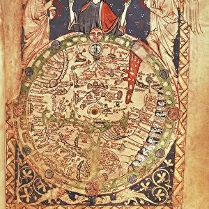
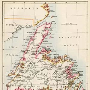
Map of Canada, New France and Neighboring Countries by Guillaume Delisle, pen drawing, created in Paris, 1696

![]()
Wall Art and Photo Gifts from Universal Images Group (UIG)
Map of Canada, New France and Neighboring Countries by Guillaume Delisle, pen drawing, created in Paris, 1696
Cartography, 17th century. Map of Canada (New France) and neighbouring countries, created by Guillaume Delisle. Paris 1696. Pen drawing. 48.8 x 64 cm
Universal Images Group (UIG) manages distribution for many leading specialist agencies worldwide
Media ID 9500089
© DEA PICTURE LIBRARY
17th Century Canada Colonialism Direction Guidance Simplicity Western Script Guillaume Delisle New France
FEATURES IN THESE COLLECTIONS
> Europe
> France
> Paris
> Maps
> North America
> Canada
> Maps
> Universal Images Group (UIG)
> Art
> Painting, Sculpture & Prints
> Illustration And Painting
EDITORS COMMENTS
This pen drawing, created by Guillaume Delisle in Paris in 1696, showcases a Map of Canada, New France, and Neighboring Countries. With its intricate details and historical significance, this map takes us back to the 17th century when colonialism was at its peak. Measuring 48.8 x 64 cm, this horizontal artwork offers a glimpse into the physical geography of North America during that era. The simplicity of the design allows for easy interpretation and serves as a valuable tool for navigation and travel. Delisle's expertise in cartography is evident through his meticulous depiction of Western script labels on various regions. This attention to detail provides clear guidance for explorers and settlers who ventured into these uncharted territories. The absence of people on this map emphasizes its focus on geographical features rather than human settlements. It highlights the vastness and untamed nature of Canada's landscape during that time period. As an illustration and painting piece from the 17th century, this artwork holds immense historical value. It sheds light on New France's influence in North America while also showcasing Delisle's artistic skill. With no commercial use intended for this print from Universal Images Group (UIG), it serves as a reminder of our rich history and invites us to explore the past through artistry and cartographic excellence.
MADE IN THE USA
Safe Shipping with 30 Day Money Back Guarantee
FREE PERSONALISATION*
We are proud to offer a range of customisation features including Personalised Captions, Color Filters and Picture Zoom Tools
SECURE PAYMENTS
We happily accept a wide range of payment options so you can pay for the things you need in the way that is most convenient for you
* Options may vary by product and licensing agreement. Zoomed Pictures can be adjusted in the Cart.