Home > Europe > Republic of Ireland > Maps
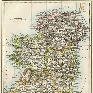
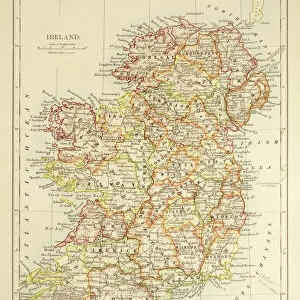
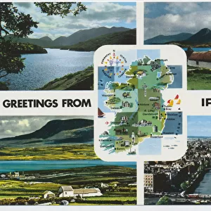
Map of Ireland, c1910. Artist: Gull Engraving Company

![]()
Wall Art and Photo Gifts from Heritage Images
Map of Ireland, c1910. Artist: Gull Engraving Company
Map of Ireland, c1910. [Encyclopaedia Britannica Co]
Heritage Images features heritage image collections
Media ID 14992233
Border Eire Encyclopedia Gull Engraving Gull Engraving Co Gull Engraving Company Ireland Irish Irish Sea Encyclopedia Britannica Inset
FEATURES IN THESE COLLECTIONS
> Europe
> Republic of Ireland
> Maps
> Maps and Charts
> Related Images
EDITORS COMMENTS
This print showcases a stunning Map of Ireland, dating back to approximately 1910. Created by the talented Gull Engraving Company, this intricate piece of art captures the essence and beauty of the Irish landscape. The map is filled with vibrant colors that bring life to every geographical feature, from its rolling hills to its majestic coastline. The close-up view allows us to appreciate the fine details and craftsmanship put into this historical artwork. Every bay and inlet is meticulously depicted, highlighting Ireland's unique relationship with the Irish Sea. The borders are neatly outlined, emphasizing the country's distinct shape and location within Europe. As we delve into this century-old map, we are transported back in time to an era when cartography was both an art form and a scientific endeavor. This print serves as a valuable resource for historians and geographers alike, providing insights into Ireland's geography during the early 20th century. With its rich history and cultural significance, this Map of Ireland holds immense value for those interested in exploring Eire's past or tracing their Irish roots. It stands as a testament to Gull Engraving Company's expertise in creating detailed engravings that have stood the test of time. This print is part of The Print Collector collection curated by Encyclopedia Britannica Co. , ensuring its authenticity and historical importance. Whether displayed on your wall or used for educational purposes, it offers a glimpse into Ireland's enchanting landscapes while celebrating centuries-old artistic mastery.
MADE IN THE USA
Safe Shipping with 30 Day Money Back Guarantee
FREE PERSONALISATION*
We are proud to offer a range of customisation features including Personalised Captions, Color Filters and Picture Zoom Tools
SECURE PAYMENTS
We happily accept a wide range of payment options so you can pay for the things you need in the way that is most convenient for you
* Options may vary by product and licensing agreement. Zoomed Pictures can be adjusted in the Cart.