Home > Arts > Street art graffiti > Digital art > Vector illustrations
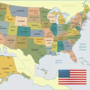
Daly City California US City Street Map

![]()
Wall Art and Photo Gifts from Fine Art Storehouse
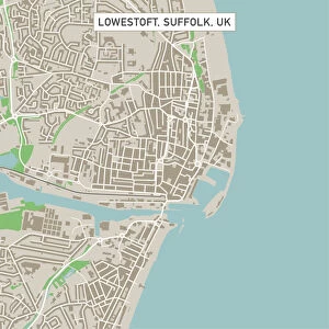
Daly City California US City Street Map
Vector Illustration of a City Street Map of Daly City, California, USA. Scale 1:60, 000.
All source data is in the public domain.
U.S. Geological Survey, US Topo
Used Layers:
USGS The National Map: National Hydrography Dataset (NHD)
USGS The National Map: National Transportation Dataset (NTD)
Unleash your creativity and transform your space into a visual masterpiece!
Frank Ramspott
Media ID 15055041
© Frank Ramspott, all rights reserved
Aerial View California City Map Computer Graphic Directly Above Downtown District Gray Pacific Ocean Road Map Text Digitally Generated Image Green Color White Color
FEATURES IN THESE COLLECTIONS
> Aerial Photography
> Related Images
> Animals
> Insects
> Hemiptera
> Green Scale
> Animals
> Mammals
> Cricetidae
> California Mouse
> Arts
> Artists
> O
> Oceanic Oceanic
> Arts
> Contemporary art
> Digital artwork
> Street art
> Arts
> Landscape paintings
> Waterfall and river artworks
> River artworks
> Arts
> Portraits
> Pop art gallery
> Street art portraits
> Arts
> Street art graffiti
> Digital art
> Digital paintings
> Arts
> Street art graffiti
> Digital art
> Vector illustrations
> Fine Art Storehouse
> Map
> Street Maps
> Fine Art Storehouse
> Map
> USA Maps
> Maps and Charts
> Geological Map
EDITORS COMMENTS
This print showcases a detailed and visually stunning city street map of Daly City, California, USA. The vector illustration captures the essence of this vibrant city with its intricate road network and various landmarks. With a scale of 1:60,000, every street and avenue is meticulously depicted to provide an accurate representation. The source data used for this artwork is in the public domain, courtesy of the U. S. Geological Survey's National Map. Layers from the National Hydrography Dataset (NHD) and National Transportation Dataset (NTD) were utilized to create this masterpiece. From the serene Lake Merced to the vast Pacific Ocean coastline, all key features are highlighted on this map print. The bustling downtown district comes alive with its array of streets and buildings while rivers meander through the landscape adding depth and charm. With no people present in this digitally generated image, attention is solely focused on the beauty of cartography itself. The color palette includes shades of gray, green, blue, and white which enhance both readability and aesthetics. Designed by Frank Ramspott exclusively for Fine Art Storehouse customers seeking unique pieces that celebrate physical geography through computer graphics. This aerial view directly above Daly City invites viewers to explore its streetscape from a fresh perspective.
MADE IN THE USA
Safe Shipping with 30 Day Money Back Guarantee
FREE PERSONALISATION*
We are proud to offer a range of customisation features including Personalised Captions, Color Filters and Picture Zoom Tools
SECURE PAYMENTS
We happily accept a wide range of payment options so you can pay for the things you need in the way that is most convenient for you
* Options may vary by product and licensing agreement. Zoomed Pictures can be adjusted in the Cart.